Daily Weather Observations for November 2020
Yuma, Arizona
Click here to see more details of the weather.


Daily Weather Observations for November 2020
Yuma, Arizona
Click here to see more details of the weather.
Travel Itinerary:
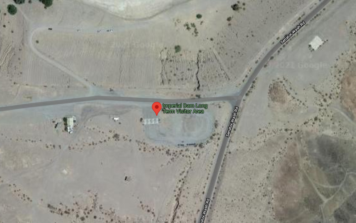
11/15/20 - Sunday
Depart From: Deming, NM
Depart: 7:55 am
Odometer: 134,429
Arrive: 4:45 pm
Odometer: 134,893
Trip Mileage: 464
Trip Time: 8 hr 50 min
Destination:
Imperial Dam LTVA
Yuma, AZ
Google Maps: 465 miles - 6 hr 50 min
Campsite: Herman's Horse Path
Cost: $180.00 from September 15 to April 15
Gas Expense:
Price/Gal:
Gallons:
Amount:
Odometer:
Comments:
So nice to be back in the desert!
Will stay here through late March/early April.


Deming is a city in Luna County, New Mexico.
Deming is the county seat and principal community of Luna County.
It is located 60 miles west of Las Cruces and 35 miles north of the Mexican
border.
The population was 14,855 as of the 2010 census.
Deming was founded in 1881 and incorporated in 1902.
It was named after Mary Ann Deming Crocker, wife of Charles Crocker, one of the
big four of the railroad industry at the time.
Travel Itinerary:
11/14/20 - Saturday
Depart From: Lamesa, TX
Depart: 10:30 am
Odometer: 134,028
Arrive: 6:50 pm
Odometer: 134,429
Trip Mileage: 401
Trip Time: 8 hr 20
Destination:
Walmart #5166
GPS: 32.270554, -107.747218
Deming, NM
Google Maps: 402 miles - 6 hr 9 min
Campsite: Walmart Parking Lot
Cost: Free
Gas Expense:
Hometown Convenience Stores
400 W Avenue A
Seminole, TX 79760
Price/Gal: $1.899
Gallons: 19.742
Amount: $37.49
Odometer: 134,070
Quick Silver
14421 Montana
El Paso, TX 79938
Price/Gal: $2.159
Gallons: 24.831
Amount: $53.61
Odometer: 134,311
Comments:
Very popular spot for RV and truck parking.
Get here early in the evening to find a spot, otherwise trucks will fill up
available spots.
Considerable noise from I-10 traffic in early evening.


Lamesa is a city in and the county seat of Dawson County, Texas.
The population was 9,422 at the 2010.
Located south of Lubbock, Texas on the Llano Estacado, Lamesa was founded in 1903.
The Llano Estacado, commonly known as the Staked Plains but perhaps more
accurately interpreted as the "palisaded" plains in geological terms, is the
southern extension of the High Plains of North America and lies south of the
Canadian River in northwest Texas and northeast New Mexico.
Most of its economy is based on cotton farming.
Travel Itinerary:
11/13/20 - Friday
Depart From: Sayreville, OK
Depart: 8:30 am
Odometer: 133,719
Arrive: 3:00 pm
Odometer: 134,028
Trip Mileage: 309
Trip Time: 6 hr 30 min
Destination:
Forrest Park (City Park)
GPS: 32.722473, -101.957771
Lamesa, TX
Google Maps: 295 miles - 4 hr 21 min
Campsite: Not Numbered (site next to water only site)
Cost: Free (can stay for 4 days free)
Gas Expense:
Flying J #723
I-40, Exit 76
Amarillo, TX
Price/Gal: $1.619
Gallons: 21.476
Amount: $34.77
Odometer: 133,840
Comments:
Nice overnight camping spot.
Can stay 4 days for free.
7 sites with 30 amp electric & water.
5 sites with water only.
Dump station.
Picnic table and trash containers behind campsites.
Playground in park.
Large area fro exercise and walking dog.


Sayre is a small city in, and the county seat of, Beckham County, in western Oklahoma. It is halfway between Oklahoma City, and Amarillo, Texas, on Interstate 40 and the former U.S. Route 66. The population was 4,375 at the 2010 census.
Sayre was named for Robert H. Sayre, a stockholder of the Choctaw, Oklahoma and Gulf Railroad.
Travel Itinerary:
11/12/20 - Thursday
Depart From: Quapaw, OK
Depart: 10:20 am
Odometer: 133,372
Arrive: 5:10 pm
Odometer: 133,719
Trip Mileage: 347
Trip Time: 6 hr 50 min
Destination:
Sayre City Park
GPS: 35.273268, -99.645267
Sayre, OK
Google Maps: 340 miles - 4 hr 53 min
Campsite: 75
Cost: $12.00
Gas Expense:
Loves #737
3900 S Radio Rd (I-40, Exit 127)
El Reno, OK
Price/Gal: $1.729
Gallons: 26.798
Amount: $46.33
Odometer: 133,603
Toll Expense - Oklahoma I-44
Entry Plaza 21: $8.50
Entry Plaza 35: $8.50
I-44 (Turner Turnpike) - Unmanned Tollbooth: $2.20
John Kilpatrick Turnpike - Unmanned Tollbooth: $2.20
Comments:
Scenic city park and campground.
This park is a gem! Stayed her once before in May 2019.
$12.00 per night camping fee.
Some sites are on gravel and some are on grass.
Pull-thru gravel sites will easily accommodate big rigs.
Electric and water at each site
Dump station located within campground.
Restrooms with flush toilets and free showers.
Large area for walking, but watch out for goathead stickers.
Only downside is the park has a lot of the goathead stickers.
Campground is located adjacent to the city golf course.
Other campground amenities include:
rodeo arena - playground - swimming pool - baseball field - tennis courts - small fishing pond.
Will spend one night here.


Downstream Casino Resort is owned and operated by the Quapaw Nation of
Oklahoma. The Quapaw Leadership's decision to build a truly upscale
state-of-the-art Casino Resort in 2008 has proven to be the gem of the four
states to this date.
Quapaw is a town in Ottawa County, Oklahoma. The population was 906 at the 2010
census.
The word "O-Gah-Pah" was chosen to represent how the Quapaw People say "Quapaw"
in the Quapaw language, and can be translated to mean "Downstream People."
In 1891 Kansas farmer Isaac Bingham moved his family south into Ottawa County.
The family established a community and opened several businesses. Quapaw Chief
John Quapaw donated land for a community school. The Kansas City, Fort Scott and
Memphis Railroad established a railroad stop and siding at the community
location. This established access to markets for hay and agricultural products
of the area. A post office was opened in the community grocery store in 1897.
The community leaders platted "New Town Quapaw," on land to the east purchased
from native Harry Whitebird. This "new" town was incorporated in 1917 as Quapaw.
Discovery of lead and zinc ores in the area resulted in this area being part of
the Tri-State mining district, and resulted in a population boom as thousands of
miners moved into the larger area. Native Americans were generally excluded from
mining, although the county had a significant proportion from several federally
recognized tribes. With the population and economic boom, new businesses were
developed. The 1920 census listed 1,394 residents. In the 1920s U. S. Route 66
was developed through Quapaw and was paved through Ottawa County by 1933. This
event was celebrated with Quapaw Chief Victor Griffin laying a zinc tablet in
the center of Main Street.
Quapaw began to lose residents as the local mining operations began to decline.
The population declined to 1,054 by 1940 and as mining activity in the area
declined, the population dropped to 850 in 1960.
Travel Itinerary:
11/11/20 - Wednesday
Depart From: Collinsville, IL
Depart: 8:55 AM
Odometer: 133,013
Arrive: 4:00 PM
Odometer: 133,372
Trip Mileage: 359
Trip Time: 7 hr 5 min
Destination:
Downstream Casino Resort
69300 East Née Rd
Quapaw, OK
Google Maps: 304 miles - 4 hr 35 min
Campsite: 23
Cost: Free
Gas Expense:
Mr Fuel - #1245 (Part of Pilot/Flying J Fuel Group)
4 Corvette Dr (I-55, Exit 52)
Litchfield, IL
Price/Gal: $2.039
Gallons: 24.090
Amount: $49.12
Odometer: 133,027
Flying J #1061
4839 W Chestnut Expr (I-44, Exit 72)
Springfield, MO
Price/Gal: $1.609
Gallons: 21.739
Amount: 34.98
Odometer: 133,299
Comments
Wonderful spot to spend the night. Free RV camping with electric and water on
paved parking lot.
Large area with grass areas to walk dogs and get exercise.
Casino has clean restrooms with a wonderful Starbucks style coffee bar with
baked pastries.


11/11/20 - Wednesday
Collinsville, IL
We stopped for lunch in Collinsville and were amused to see their unique water tower.
Collinsville, Illinois is famous for its enormous 170-foot Brooks Catsup
Bottle water tower and its stature as the horseradish capital of the world.
Collinsville is a city located mainly in Madison County, and partially in St.
Clair County, both in Illinois. As of the 2010 census, the city had a population
of 25,579.
Collinsville was settled in the early 1800’s and named for the Collins family
who came to the area from Litchfield, Connecticut. Flour, lumber and whiskey
were early products of the fledgling community. But it was the discovery of coal
beneath the soil in Collinsville that catapulted the city into the modern age
and brought an influx of residents.
Annual Festivals:
Italian Festival
Known for its large Italian population, descendants of late 19th and 20th
Century immigrants, the city hosts the largest Italian Festival in the Midwest
the third weekend of September each year. More than 50,000 visitors flock to the
streets of Uptown Collinsville for Italian food, grape stomping competitions,
music and culture during the two day street fest.
International Horseradish Festival
The two-day is held in June.
Collinsville reportedly produces 85 percent of the world’s horseradish.
Smokin’ on Main Barbeque
This festival is held the last weekend in July. Barbeque competitions, food
vendors, music and more are part of this street festival celebrating the outdoor
cooking skills of local and national competitors.
Historic Attractions:
Willoughby Heritage Farm
The farm, tucked away in Collinsville’s residential area, is a time machine
visit back to 1940’s middle America. The farmhouse is restored to its original
character and free tours are available daily. The 30-acre wildlife preserve has
hiking trails and scenic vistas overlooking the surrounding prairie.
D.D. Collins House
Tour the historic house at 703 W. Main St., in Collinsville. The Greek revival
home was built in 1845 by the first president of the Collinsville Village Board,
Judge Daniel Collins. The home is open for tours on Saturdays from 11 a.m. to 3
p.m.
Cahokia Mounds
Collinsville is home to the largest and most civilized prehistoric culture north
of Mexico. What is now called the Cahokia Mounds Historic Site sits on the
southwest edge of the city. Within the 2,000 acre tract of the preserved
settlement lies the archeological remains of the Mississippians and their
ancient civilization known today as Cahokia. The Native Americans in the region
built over 80 man-made mounds and 70 still exist. The mounds were used for
ceremonial and burial purposes and visitors can stroll through the grounds and
explore the remaining mounds. Cahokia Mounds is a UNESCO World Heritage Site and
Historical Landmark.
For more information on Collinsville click here: Collinsville.


Waggoner is a village in Montgomery County, Illinois.
The population was 245 at the 2000 census.
Travel Itinerary:
Date: 11/10/20 - Tuesday
Depart From: Chicago, IL
Depart: 2:30 pm
Odometer Start: 132,769
Arrive: 8:00 pm
Odometer End: 133,013
Trip Mileage: 244
Trip Time: 6 hr 30 min
Destination:
Waggoner, IL
Rest Area, I-55, MM-64
Very large, well maintained rest area.
Comments:
We departed today for our winter home near Yuma, AZ.
Encountered gusty winds up to 45 mph out of the south.
Tornado warnings issued throughout northern Illinois.
On I-39, just south of I-80, a fierce rain storm created zero visibility.
With winds gusting up to 70 mph, we had to exit I-39 and pull into a truck stop for
shelter.
After about 45 minutes the rain storm had diminished significantly to allow travel
to continue.
The overhead traffic light at the truck stop had been ripped from it's moorings and fell
to the pavement.
We will the spend the night at the Coalfield rest area on I-55, near Waggoner, IL, 25 miles south of Springfield, IL.


