Tuessday – July 12, 2016
Crater Lake National Park
Klamath Falls, Oregon
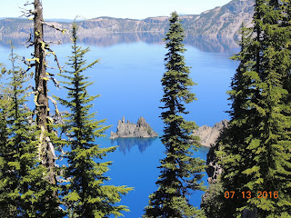
Our first view of Crater Lake left us speechless and awestruck! Words cannot adequately describe the scenic wonder of this spiritual area that is central to the cultural traditions of local American Indian tribes.
Crater Lake National Park Facts:
Park established in 1902
Size: 183,224 acres
Lake Depth: 1,943 feet
Lake Width: 4.5 to 6 miles
Annual Snowfall: 44 feet
Crater Lake National Park protects the deepest lake in the United States. Crater Lake has no streams flowing into or out of it. All water that enters the lake is eventually lost from evaporation or subsurface seepage. The lake is re-filled entirely from direct precipitation in the form of snow and rain. The lake is considered to be the cleanest large body of water in the world. The water is exceptional for its clarity and intense blue color.
The lake resides inside a caldera and is 1,949 feet deep at its deepest point, which makes it the deepest lake in the United States, the second deepest in North America and the ninth deepest in the world. The impressive average depth of this volcanic lake is due to the nearly symmetrical 4,000-foot deep caldera formed 7,700 years ago during the violent climactic eruptions and subsequent collapse of Mount Mazama, a 12,000-foot-tall volcano. The eruption may have been the largest in North America in the past 640,000 years. The caldera rim ranges in elevation from 7,000 to 8,000 feet. The elevation of the lake surface itself is 6,178 feet.
About 400,000 years ago, Mount Mazama began its existence in much the same way as the other mountains of the Cascade Range, as overlapping shield volcanoes. Over time, alternating layers of lava flows and pyroclastic flows built Mazama's overlapping cones until it reached about 12,000 feet in height. Around 5700 BC, Mazama collapsed into itself during a tremendous volcanic eruption, losing 2,500 to 3,500 feet in height. The eruption formed a large caldera that, depending on the prevailing climate, was filled in about 740 years, forming a beautiful lake known today as Crater Lake. The Mazama eruption produced more than 150 times as much ash as the May 18, 1980 eruption of Mount St. Helens.
Volcanic activity in this area is fed by subduction off the coast of Oregon as the Juan de Fuca Plate slips below the North American Plate. Heat and compression generated by this movement has created a mountain chain topped by a series of volcanoes, which together are called the Cascade Range.
Mammals that are residents of this national park are Canadian lynxes, bobcats, beavers, chipmunks, pikas, foxes, cougars, squirrels, porcupines, black bears, brown bears, coyotes, timber wolves, badgers, deer, elk, muskrats, and martens. Birds that commonly fly through this park including raptors are American dippers, Peregrine falcons, ravens, Clark's nutcrackers, gray jays, bald eagles, hummingbirds and spotted owls while Canada geese float on its lake.
We explored Crater Lake via the Rim Drive. This is a 33-mile road that encircles Crater Lake. It is one of America’s most scenic byways, with spectacular views in all directions. Our "Must-See" stops included:
Discovery Point
It was near this spot, on the back of a mule in 1853, that gold prospector
John Hillman became the first European-American to stumble across what he called
"Deep Blue Lake."
Watchman Overlook
This overlook offers an unmatched view of Wizard Island, a cinder cone that
erupted out of Crater Lake 7,300 years ago.
Cloudclap Overlook
This site sits at the end of a 1-mile spur road, the highest paved road in
Oregon. Whitebark pines cling for survival here, dwarfed and contorted by the
harsh winds.
Pumice Castle Overlook
This is one of the park’s most colorful features: a layer of orange pumice
rock that has been eroded into the shape of a medieval castle.
Phantom Ship Overlook
Nestled against the shore, Crater Lakes "other island" resembles a small
sailboat, although it is as tall as a 16-story building. It’s made of
erosion-resistant lava, 400,000 years old – the oldest exposed rock within the
caldera.
Pinnacles Overlook
Colorful spires, 100 feet tall, are being eroded from the canyon wall. The
Pinnacles are "fossil fumaroles" where volcanic gases once rose up through a
layer of volcanic ash, cementing the ash into solid rock.
Vidae Falls
A spring-fed creek tumbles over a glacier-carved cliff and drops 100 feet
over a series of ledges. In summer, wildflowers flourish in the cascade’s spray.
Tomorrow another adventure begins.


No comments:
Post a Comment